Ben Noll(@BenNollWeather) 's Twitter Profileg
Ben Noll

@BenNollWeather

Meteorologist, National Institute of Water & Atmospheric Research, New Zealand | Climate science | Maps | #HudsonValley snow days | Tweets mine

ID:2236923048

linkhttps://www.bennollweather.com calendar_today09-12-2013 03:13:51

19,1K Tweets

74,0K Followers

154 Following

Follow People
Ben Noll(@BenNollWeather) 's Twitter Profile Photo

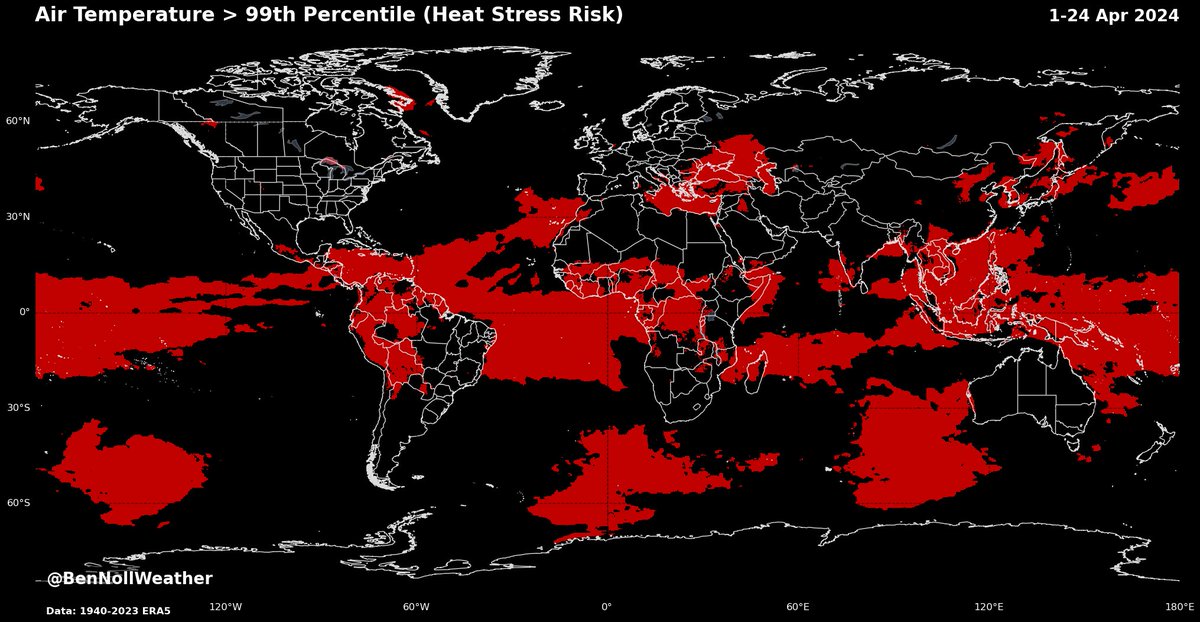
It may be cool in your corner of the world, but a large proportion of the planet is experiencing excessive heat, especially in the tropical band 🔥

This map highlights areas (🔴) where temperatures during April were above the 99th percentile for the month (very unusually warm /

It may be cool in your corner of the world, but a large proportion of the planet is experiencing excessive heat, especially in the tropical band 🔥 This map highlights areas (🔴) where temperatures during April were above the 99th percentile for the month (very unusually warm /
account_circle
Ben Noll(@BenNollWeather) 's Twitter Profile Photo

What a difference a week makes: the will go from having lows in the 20s this past week to highs in the 70s (and maybe 80s) this coming week 🎢

It comes as a high pressure system is setting up shop over the Southeast U.S., drawing warm air up from Texas initially
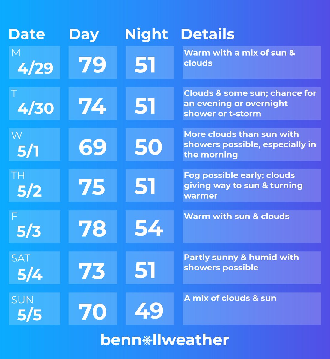
What a difference a week makes: the #HudsonValley will go from having lows in the 20s this past week to highs in the 70s (and maybe 80s) this coming week 🎢 It comes as a high pressure system is setting up shop over the Southeast U.S., drawing warm air up from Texas initially
account_circle
Ben Noll(@BenNollWeather) 's Twitter Profile Photo

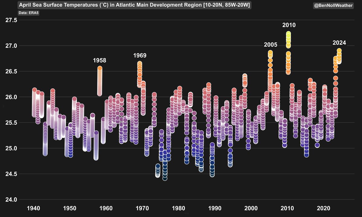
As of April, only 2010 had warmer sea surface temperatures in the Atlantic Main Development Region than 2024.

Only a few years are in the same realm as 2024: 2023, 2010, 2005, 1969, and 1958.

These years featured notable and in some cases historical hurricane impacts like

As of April, only 2010 had warmer sea surface temperatures in the Atlantic Main Development Region than 2024. Only a few years are in the same realm as 2024: 2023, 2010, 2005, 1969, and 1958. These years featured notable and in some cases historical hurricane impacts like
account_circle
Ben Noll(@BenNollWeather) 's Twitter Profile Photo

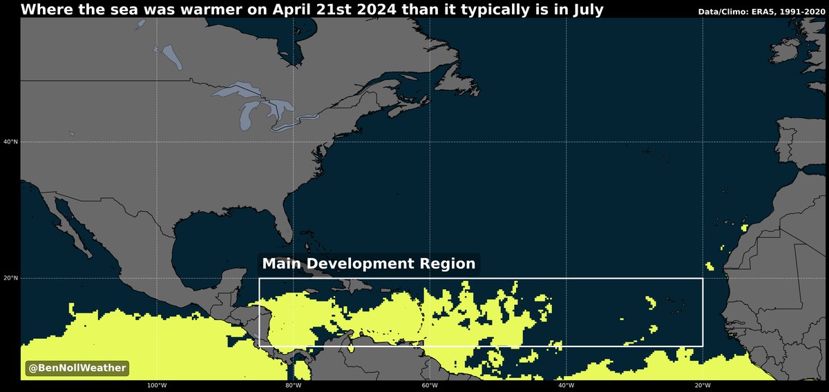
❗️ About 40% of the Atlantic Main Development Region (for hurricanes) is currently warmer in late April than it typically is in July...

This is why forecasters are keeping such a close eye on hurricane season this year: the seas are off-the-charts warm where the strongest

❗️ About 40% of the Atlantic Main Development Region (for hurricanes) is currently warmer in late April than it typically is in July... This is why forecasters are keeping such a close eye on hurricane season this year: the seas are off-the-charts warm where the strongest
account_circle
Ben Noll(@BenNollWeather) 's Twitter Profile Photo

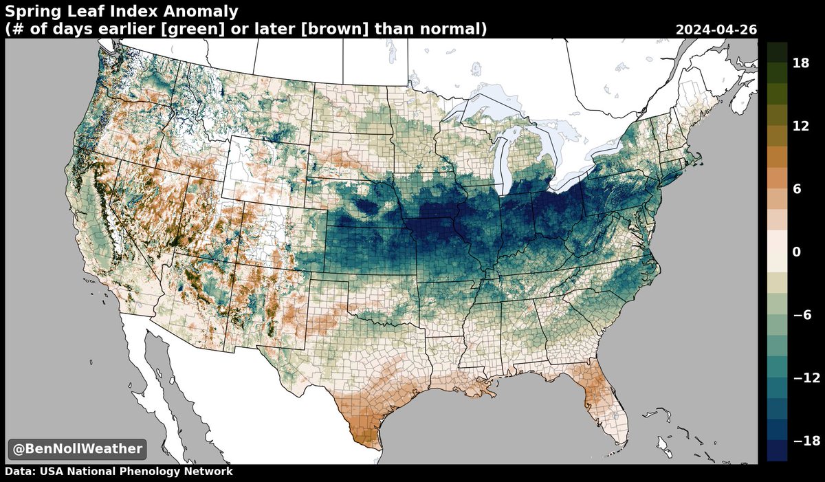
Spring 'leaf out' is a solid 1-3+ weeks ahead of schedule (🟢) across the central states & some eastern states 🌳

A combination of wet & relatively warm conditions has done the trick.

Sneezy season is definitely upon us: pollen counts are going up! 📈

Spring 'leaf out' is a solid 1-3+ weeks ahead of schedule (🟢) across the central states & some eastern states 🌳 A combination of wet & relatively warm conditions has done the trick. Sneezy season is definitely upon us: pollen counts are going up! 📈
account_circle
Ben Noll(@BenNollWeather) 's Twitter Profile Photo

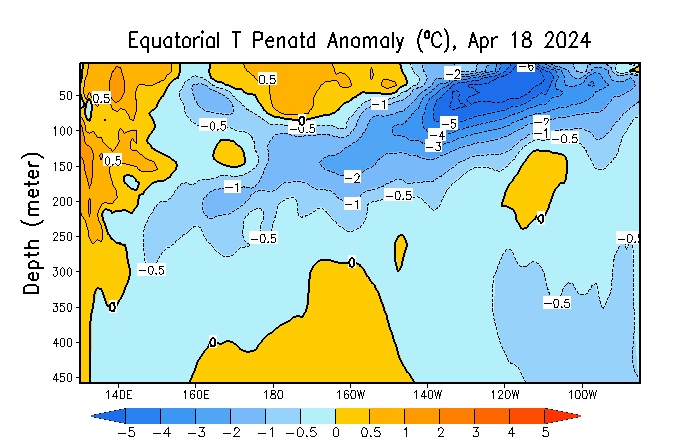
The Niño 1+2 Index in the far eastern Pacific recently dipped to -0.8˚C 📉

Sub-surface ocean waters in the eastern equatorial Pacific are *4-6˚C below average* — oceanic Kelvin Wave activity and periodic trade wind enhancements should see this cold pool move toward the ocean

The Niño 1+2 Index in the far eastern Pacific recently dipped to -0.8˚C 📉 Sub-surface ocean waters in the eastern equatorial Pacific are *4-6˚C below average* — oceanic Kelvin Wave activity and periodic trade wind enhancements should see this cold pool move toward the ocean
account_circle
Ben Noll(@BenNollWeather) 's Twitter Profile Photo

I think most of the would sign up for a bit of cool weather if it meant that there wouldn’t be much rain. Am I right?

Many of us would probably favor some proper “spring weather” rather than surging directly into summer-like heat.

It seems Mother Nature’s tantrum
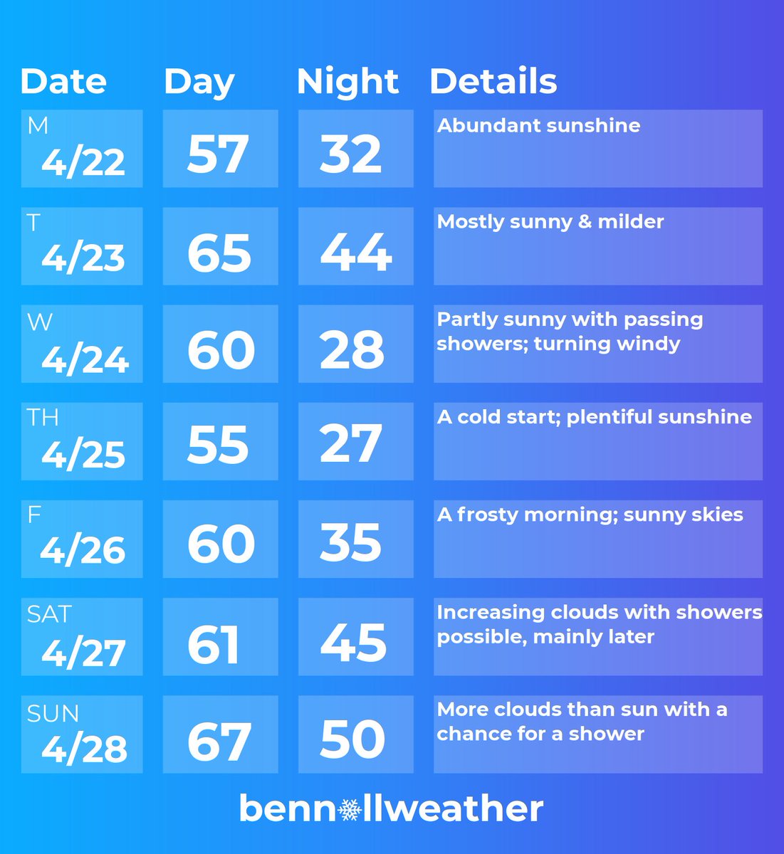
I think most of the #HudsonValley would sign up for a bit of cool weather if it meant that there wouldn’t be much rain. Am I right? Many of us would probably favor some proper “spring weather” rather than surging directly into summer-like heat. It seems Mother Nature’s tantrum
account_circle
Ben Noll(@BenNollWeather) 's Twitter Profile Photo

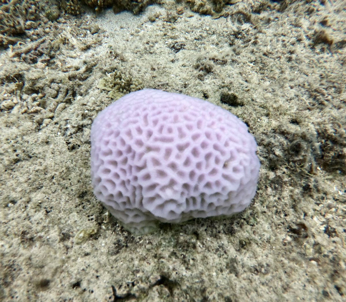
Have you ever seen a coral that looks like a brain? 🧠

It’s called, as you could have guessed, “brain coral”.

It’s so smart that it knows how to live for up to 900 years 🤓

Have you ever seen a coral that looks like a brain? 🧠 It’s called, as you could have guessed, “brain coral”. It’s so smart that it knows how to live for up to 900 years 🤓
account_circle
Ben Noll(@BenNollWeather) 's Twitter Profile Photo

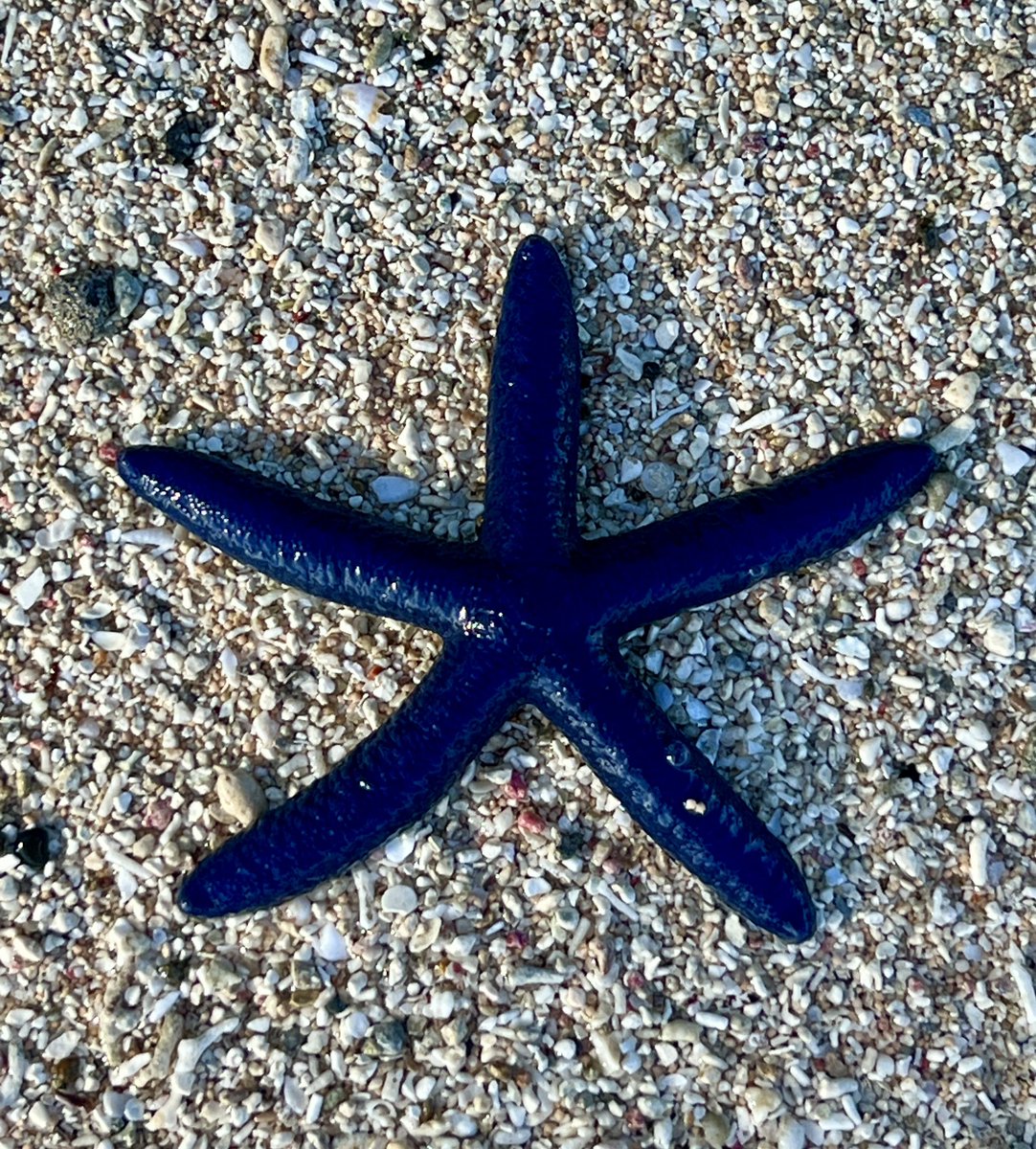
Have you ever seen a blue sea star⁉️

They live in the shallow waters of the tropical Indo-Pacific region & enjoy sunny areas of reef systems 🌟

I spotted this one on the Coral Coast, Fiji.

Have you ever seen a blue sea star⁉️ They live in the shallow waters of the tropical Indo-Pacific region & enjoy sunny areas of reef systems 🌟 I spotted this one on the Coral Coast, Fiji.
account_circle
Ben Noll(@BenNollWeather) 's Twitter Profile Photo

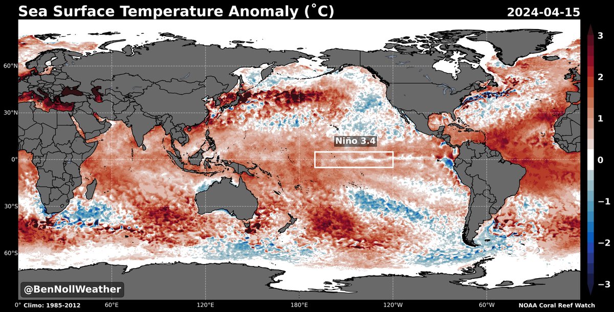
The key El Niño monitoring region in the central Pacific, Niño 3.4, recently recorded an anomaly of *less than* +0.5˚C for the first time since May 2023.

Oceanic El Niño continues to fade 📉

Convective forcing will favor the Atlantic instead of the Pacific in the months ahead.

The key El Niño monitoring region in the central Pacific, Niño 3.4, recently recorded an anomaly of *less than* +0.5˚C for the first time since May 2023. Oceanic El Niño continues to fade 📉 Convective forcing will favor the Atlantic instead of the Pacific in the months ahead.
account_circle
Ben Noll(@BenNollWeather) 's Twitter Profile Photo

If you are thinking of traveling overseas, the tropical South Pacific has a lot to offer! 🌴

The dry season runs from May-October, while the wet (cyclone) season is from November-April.

I’m here to help Pacific Island meteorological services with the six month climate outlook.

account_circle
Ben Noll(@BenNollWeather) 's Twitter Profile Photo

Sustained warmth is not yet in Mother Nature’s plans for the , but Monday-Wednesday isn’t looking too bad...

After the chance for a gusty shower or thunderstorm in the region this (Sunday) afternoon or evening, Monday and Tuesday look to be the warmest days of the
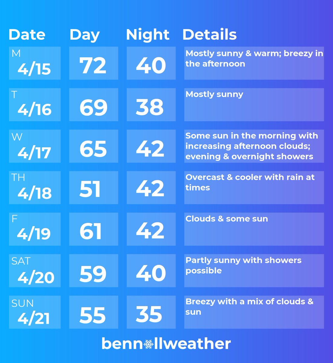
Sustained warmth is not yet in Mother Nature’s plans for the #HudsonValley, but Monday-Wednesday isn’t looking too bad... After the chance for a gusty shower or thunderstorm in the region this (Sunday) afternoon or evening, Monday and Tuesday look to be the warmest days of the
account_circle
Ben Noll(@BenNollWeather) 's Twitter Profile Photo

The latest ECMWF+UKMET 'superblend' for the heart of hurricane season continues to suggest a very active pattern in the Atlantic.

It seems to favor east-to-west tracks & not recurving systems.

Above normal precipitation covers the Gulf of Mexico & Southeast...

Mark Sudduth

The latest ECMWF+UKMET 'superblend' for the heart of hurricane season continues to suggest a very active pattern in the Atlantic. It seems to favor east-to-west tracks & not recurving systems. Above normal precipitation covers the Gulf of Mexico & Southeast... @hurricanetrack
account_circle