Pete Delkus(@wfaaweather) 's Twitter Profileg
Pete Delkus

@wfaaweather

I'm just your weather guy.

ID:15937025

linkhttps://www.wfaa.com/article/about-us/team-bios/pete-delkus/287-28580021 calendar_today21-08-2008 21:15:45

73,1K Tweets

453,6K Followers

153 Following

Pete Delkus(@wfaaweather) 's Twitter Profile Photo

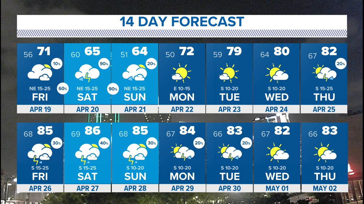
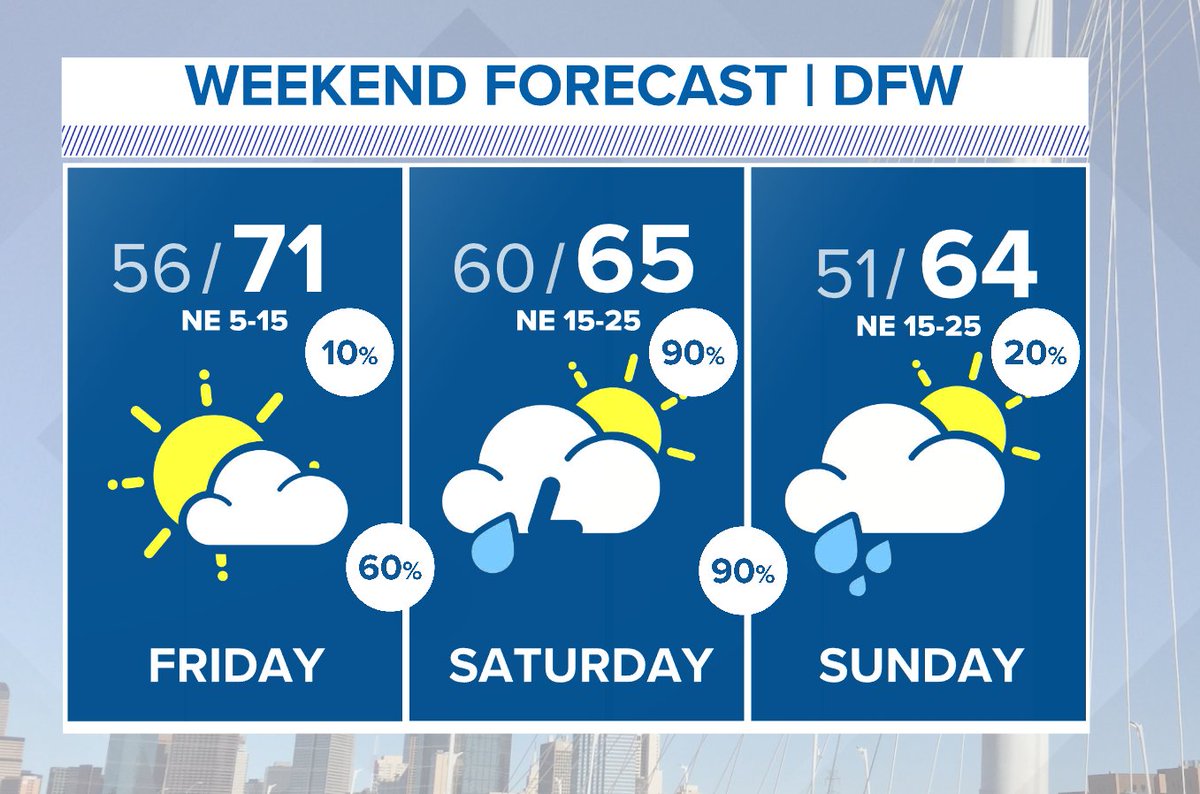
A better opportunity for rain comes this weekend. Widespread showers and storms will be possible Friday night through Sunday morning. There will be some breaks in the rain. Storms are most likely Saturday morning with heavier, soaking rain Saturday evening.

A better opportunity for rain comes this weekend. Widespread showers and storms will be possible Friday night through Sunday morning. There will be some breaks in the rain. Storms are most likely Saturday morning with heavier, soaking rain Saturday evening. #wfaaweather
account_circle
Pete Delkus(@wfaaweather) 's Twitter Profile Photo

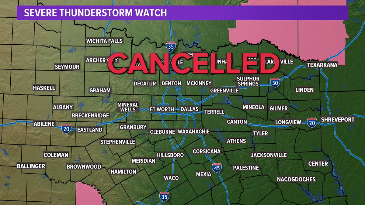
Severe Thunderstorm Watch has been cancelled for all of North Texas. The cap held! An isolated shower is still possible, but the threat for severe weather has ended.
Rain is in the forecast Friday night through Saturday morning.

Severe Thunderstorm Watch has been cancelled for all of North Texas. The cap held! An isolated shower is still possible, but the threat for severe weather has ended. Rain is in the forecast Friday night through Saturday morning. #wfaaweather
account_circle
Pete Delkus(@wfaaweather) 's Twitter Profile Photo

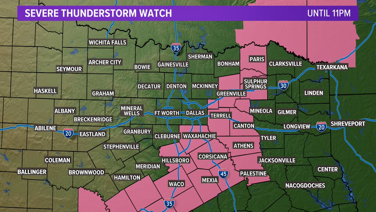
The Severe Thunderstorm Watch has been cancelled for Collin, Dallas, and Fannin counties. It still continues for areas east of DFW in eastern and southern North Texas until 11pm tonight.

The Severe Thunderstorm Watch has been cancelled for Collin, Dallas, and Fannin counties. It still continues for areas east of DFW in eastern and southern North Texas until 11pm tonight. #wfaaweather
account_circle
Pete Delkus(@wfaaweather) 's Twitter Profile Photo

6:45pm update: A few showers are trying to develop in Dallas county as a cold front continues to push through DFW.

A Severe Thunderstorm Watch continues until 11pm.

account_circle
Pete Delkus(@wfaaweather) 's Twitter Profile Photo

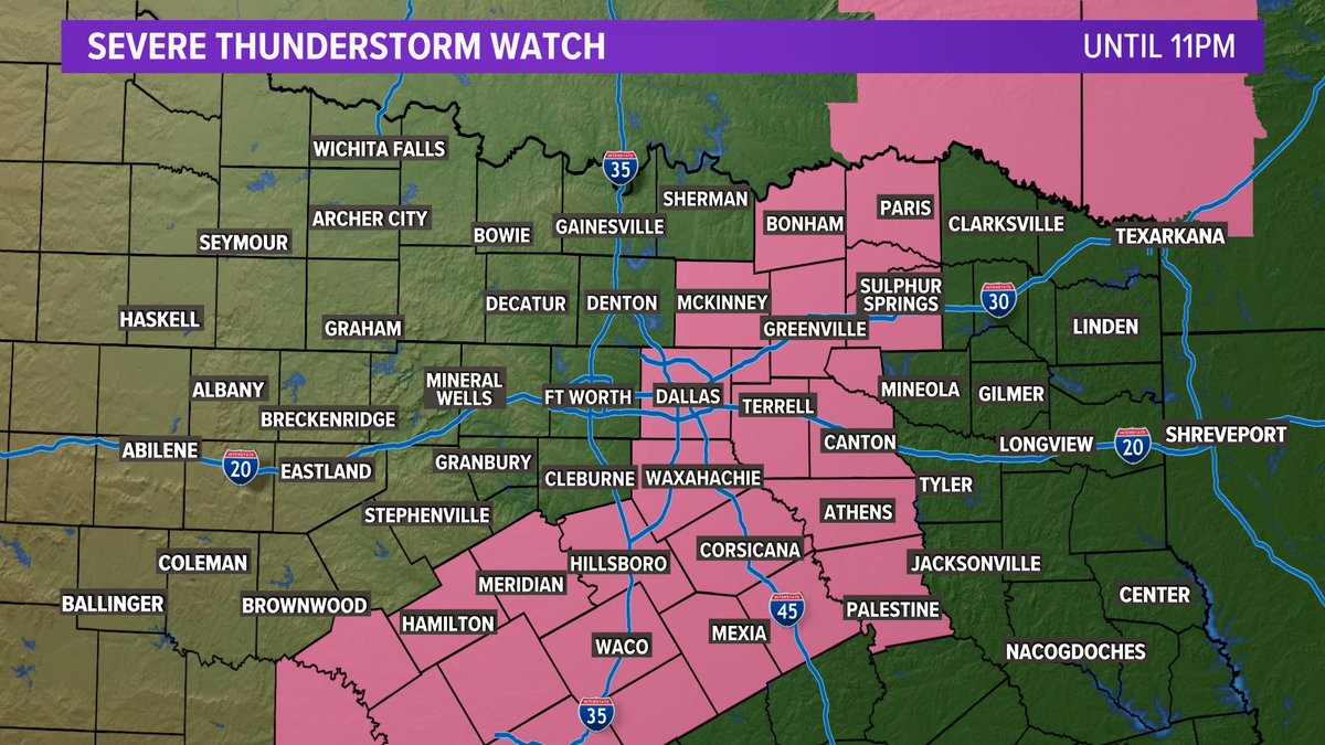
A Severe Thunderstorm Watch has been issued for the eastern half of North Texas until 11pm. It does included Dallas and Collin Counties in the DFW area. However, the window for storms in those counties is really over the next 1-2 hours.

A Severe Thunderstorm Watch has been issued for the eastern half of North Texas until 11pm. It does included Dallas and Collin Counties in the DFW area. However, the window for storms in those counties is really over the next 1-2 hours. #wfaaweather
account_circle
Pete Delkus(@wfaaweather) 's Twitter Profile Photo

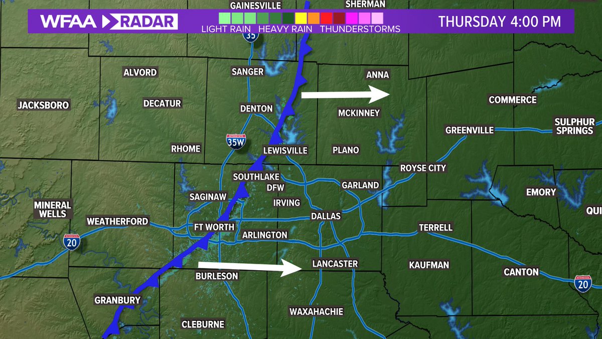
4pm Update: Front is about 1/3 of the way thru DFW. Areas behind the front = no storms today. Areas ahead of the front could still see an isolated storm before the front passes. For DFW the window is between now and about 6pm or so.

Radar: wfaa.com/radar

4pm Update: Front is about 1/3 of the way thru DFW. Areas behind the front = no storms today. Areas ahead of the front could still see an isolated storm before the front passes. For DFW the window is between now and about 6pm or so. #wfaaweather Radar: wfaa.com/radar
account_circle
Pete Delkus(@wfaaweather) 's Twitter Profile Photo

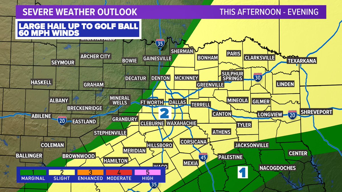
Today's severe weather outlook has been updated to remove counties in western North Texas out of the marginal risk for severe weather. The threat looks slightly higher east of DFW this evening. Storms will be isolated, not everyone sees rain.

Today's severe weather outlook has been updated to remove counties in western North Texas out of the marginal risk for severe weather. The threat looks slightly higher east of DFW this evening. Storms will be isolated, not everyone sees rain. #wfaaweather
account_circle
Pete Delkus(@wfaaweather) 's Twitter Profile Photo

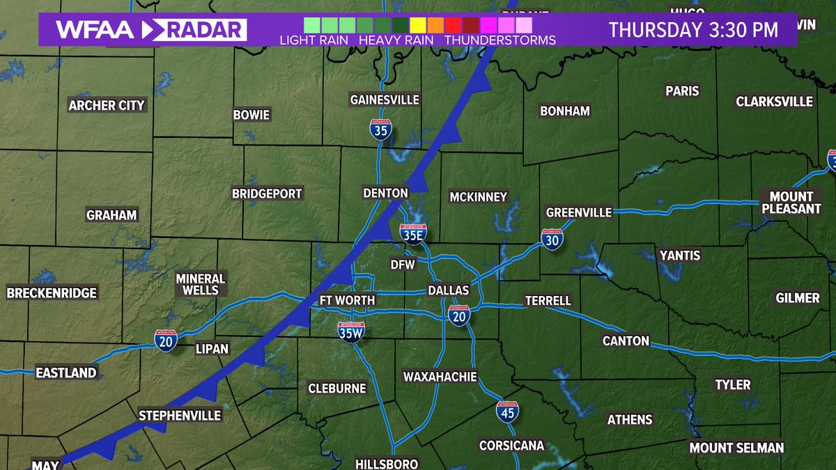
3:30pm update: A cold front is pushing through DFW from west to east. As of now, no storms have developed. If storms develop, it'll be along and east of the cold front. Temps are in the 80s ahead of the front, 70s behind the front.

3:30pm update: A cold front is pushing through DFW from west to east. As of now, no storms have developed. If storms develop, it'll be along and east of the cold front. Temps are in the 80s ahead of the front, 70s behind the front. #wfaaweather
account_circle
Pete Delkus(@wfaaweather) 's Twitter Profile Photo

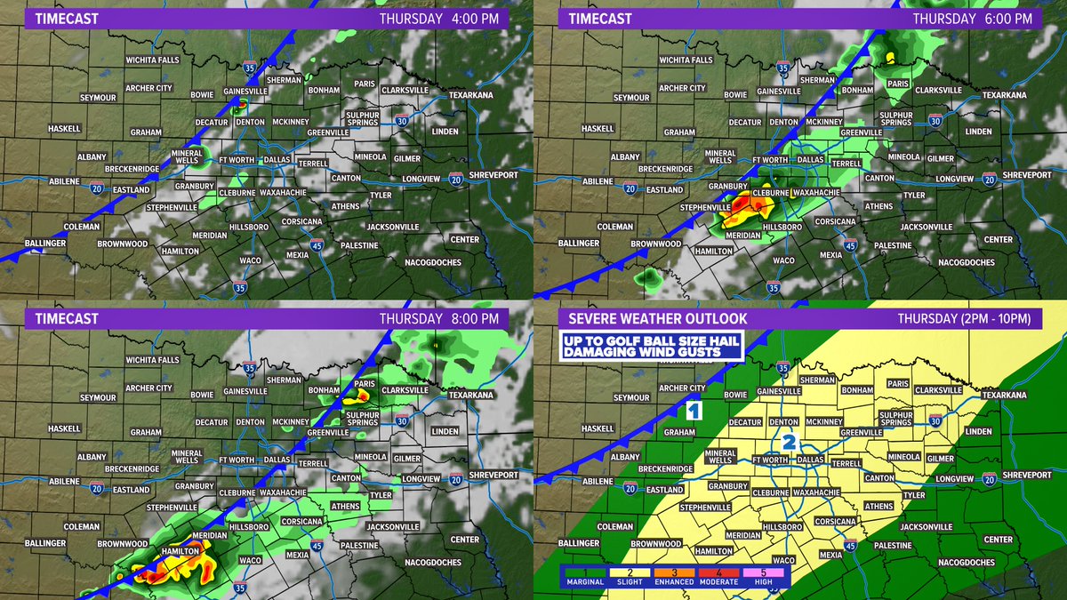
Reminder, we have storm chances and a severe threat on Thursday. Not everyone will see storms or severe weather, but storms will be out there (DFW: 4-7pm). Main threats with any severe storm are large hail and damaging winds. Stay weather aware!

Reminder, we have storm chances and a severe threat on Thursday. Not everyone will see storms or severe weather, but storms will be out there (DFW: 4-7pm). Main threats with any severe storm are large hail and damaging winds. Stay weather aware! #wfaaweather
account_circle
Pete Delkus(@wfaaweather) 's Twitter Profile Photo

Entire weekend will not be a washout as most of Sunday will be dry. However, Saturday will be rainy as rounds of rain are possible during the day into the night. Severe threat this weekend is very low and rain totals thru the weekend could be around 1-2in for the area.

account_circle
Pete Delkus(@wfaaweather) 's Twitter Profile Photo

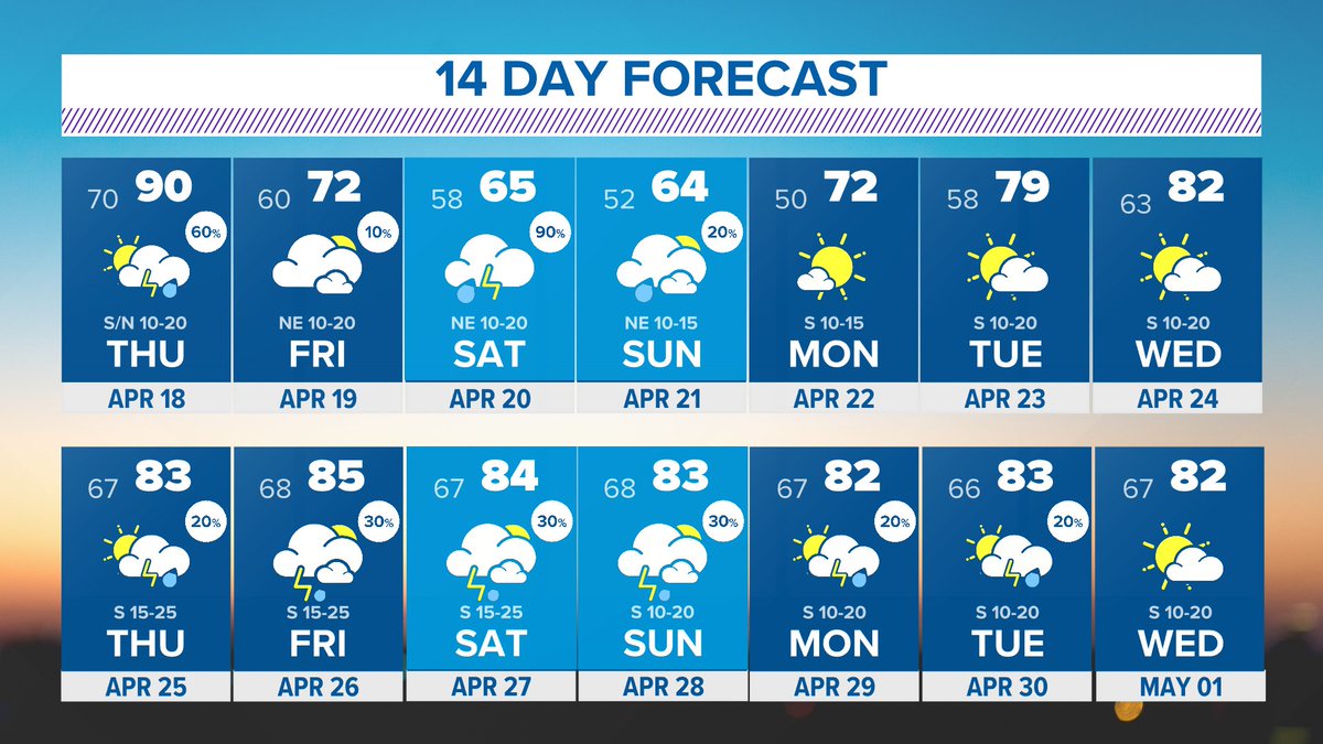
Quite the cool-down on the way this weekend. Enjoy the 60s for highs...it may be a long time before we see that again!

Quite the cool-down on the way this weekend. Enjoy the 60s for highs...it may be a long time before we see that again! #wfaaweather
account_circle
Pete Delkus(@wfaaweather) 's Twitter Profile Photo

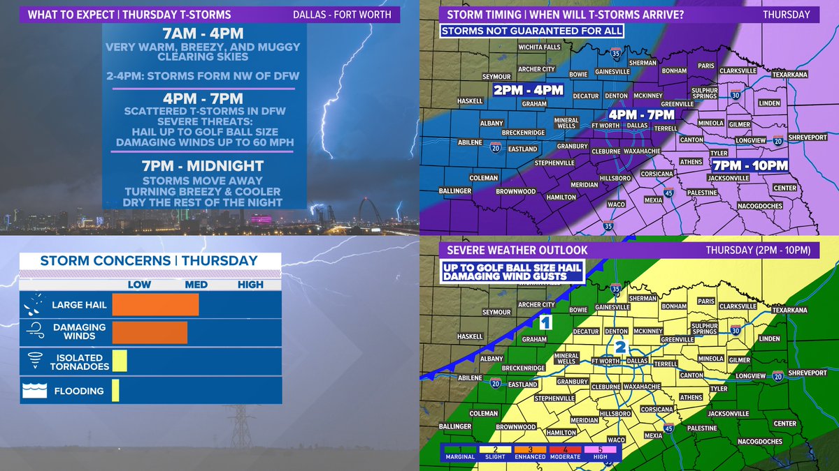
Quick window for storms Thursday afternoon and evening with DFW being around 4-7pm. Not everyone will see storms or severe weather, but any severe storms will be capable of large hail and damaging winds. Stay weather aware if you have evening plans!

Quick window for storms Thursday afternoon and evening with DFW being around 4-7pm. Not everyone will see storms or severe weather, but any severe storms will be capable of large hail and damaging winds. Stay weather aware if you have evening plans! #wfaaweather
account_circle
Pete Delkus(@wfaaweather) 's Twitter Profile Photo

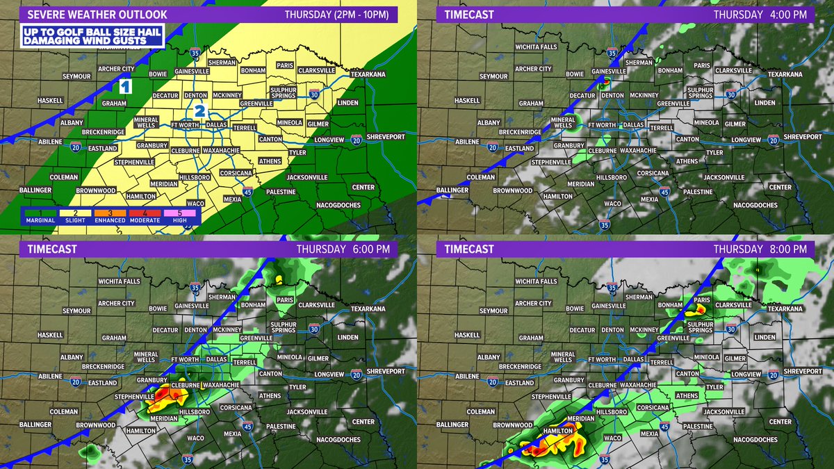
Severe storm chances Thursday:
A round of storms will form along a front Thu. afternoon into evening.
Timing for all of North Texas is from around 2-10pm with a narrower window of 4-7pm for DFW.
Some storms could be severe with large hail and damaging winds the main threats.

Severe storm chances Thursday: A round of storms will form along a front Thu. afternoon into evening. Timing for all of North Texas is from around 2-10pm with a narrower window of 4-7pm for DFW. Some storms could be severe with large hail and damaging winds the main threats.
account_circle
Pete Delkus(@wfaaweather) 's Twitter Profile Photo

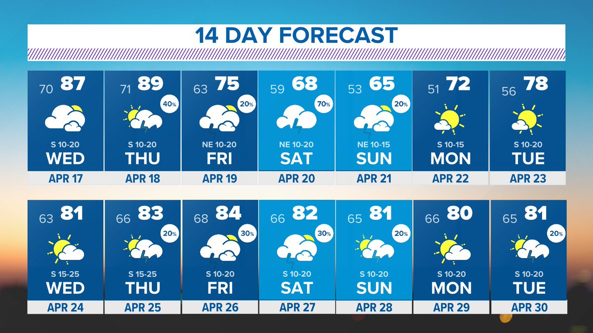
Thursday: Scattered eve/night storms, some strong to severe
Friday: Mainly dry but some isolated rain possible
Saturday: Widespread rain returns from north to south, especially PM-night
Sunday: Lingering AM rain, but moving quickly east

account_circle
Pete Delkus(@wfaaweather) 's Twitter Profile Photo

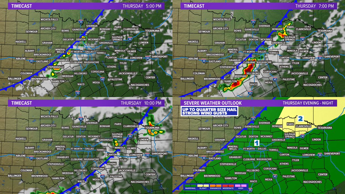
THURSDAY: Most of the day will be rain-free, but as a front moves in scattered t-storms are possible along it. Not everyone will see rain and the severe threat is low, but not zero. Can't rule out some storms with severe hail and strong wind gusts Thursday evening-night.

THURSDAY: Most of the day will be rain-free, but as a front moves in scattered t-storms are possible along it. Not everyone will see rain and the severe threat is low, but not zero. Can't rule out some storms with severe hail and strong wind gusts Thursday evening-night.
account_circle