Christina Gropp(@wxchristina) 's Twitter Profileg
Christina Gropp

@wxchristina

Meteorologist | Science Producer at IBHS | Wife to @wxandthings | @penn_state Alumna | Views, my own.

ID:902309286

linkhttp://ibhs.org calendar_today24-10-2012 18:07:45

16,0K Tweets

1,2K Followers

933 Following

Christina Gropp(@wxchristina) 's Twitter Profile Photo

Repairing your roof is the best time to make it more resilient for the next storm. Ask your roofer to reroof to the FORTIFIED standard to be better protected from wind and rain. And IBHS’s hail impact shingle ratings can help you pick a better shingle ibhs.org/impactratings

account_circle
NOAA WRN Ambassadors(@WRNAmbassadors) 's Twitter Profile Photo

Active weather is expected this week across much of the country.
A good reminder that knowing your safe place and being is a 365 day/year effort.
And on Wednesday (April 3) we invite everyone to participate in Day and challenge others.

Active weather is expected this week across much of the country. A good reminder that knowing your safe place and being #WeatherReady is a 365 day/year effort. And on Wednesday (April 3) we invite everyone to participate in #SafePlaceSelfie Day and challenge others.
account_circle
NWS Columbia(@NWSColumbia) 's Twitter Profile Photo

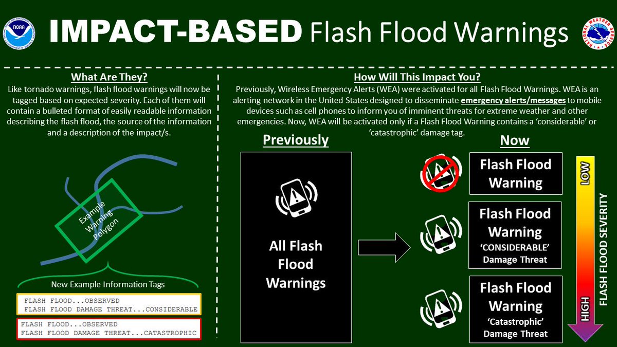
Did you know that not all severe weather warnings will activate the Wireless Emergency Alert (WEA) system? This is one reason why it is important to have at least TWO ways to receive our warnings. ALL Tornado Warnings are sent out over WEA.

Did you know that not all severe weather warnings will activate the Wireless Emergency Alert (WEA) system? This is one reason why it is important to have at least TWO ways to receive our warnings. ALL Tornado Warnings are sent out over WEA. #CAEWx #GAWx
account_circle
NWS Columbia(@NWSColumbia) 's Twitter Profile Photo

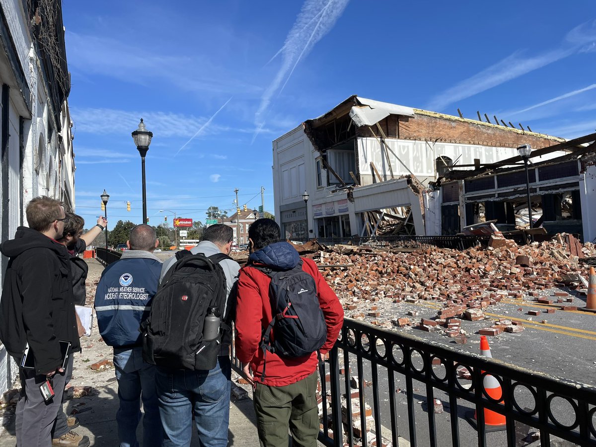
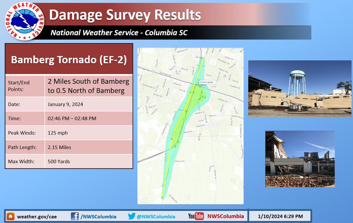
A second survey team confirmed an EF-2 in Bamberg that occurred yesterday (1/9/24). This is the second confirmed tornado from yesterday's event.

A second survey team confirmed an EF-2 #tornado in Bamberg that occurred yesterday (1/9/24). This is the second confirmed tornado from yesterday's event. #caewx #scwx
account_circle
NWS Columbia(@NWSColumbia) 's Twitter Profile Photo

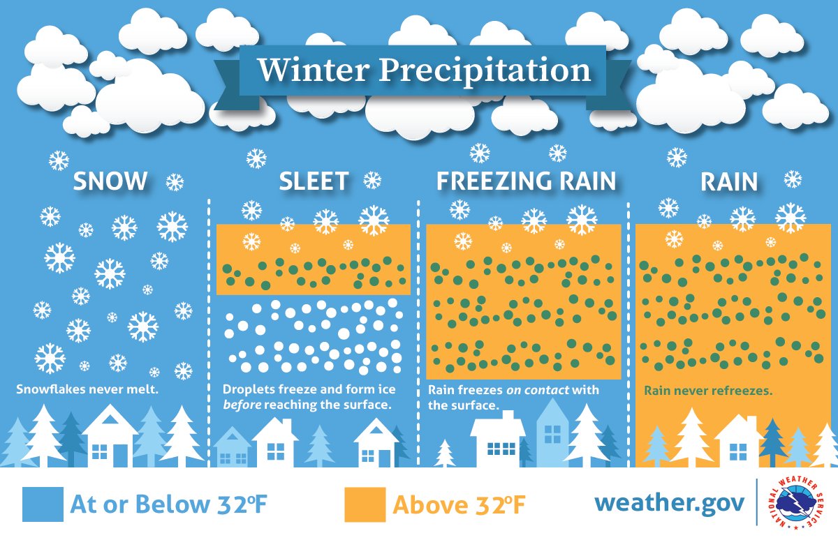
Do you know the differences between the three frozen precipitation types we can get during the winter? Here's a tasty image showing you how different , , and can look! Learn more during our winter weather preparedness weeks starting next Sunday!

Do you know the differences between the three frozen precipitation types we can get during the winter? Here's a tasty image showing you how different #snow, #sleet, and #freezingrain can look! Learn more during our winter weather preparedness weeks starting next Sunday! #CAEWx
account_circle
FEMA(@fema) 's Twitter Profile Photo

TODAY: There will be a nationwide emergency alert test on cell phones, wireless devices, radios, and TVs.

2:20 p.m. ET
1:20 p.m. CT
12:20 p.m. MT
11:20 a.m. PT
10:20 a.m. AKT
8:20 a.m. HT

Information from Deanne Criswell ⤵️

account_circle
NOAA(@NOAA) 's Twitter Profile Photo

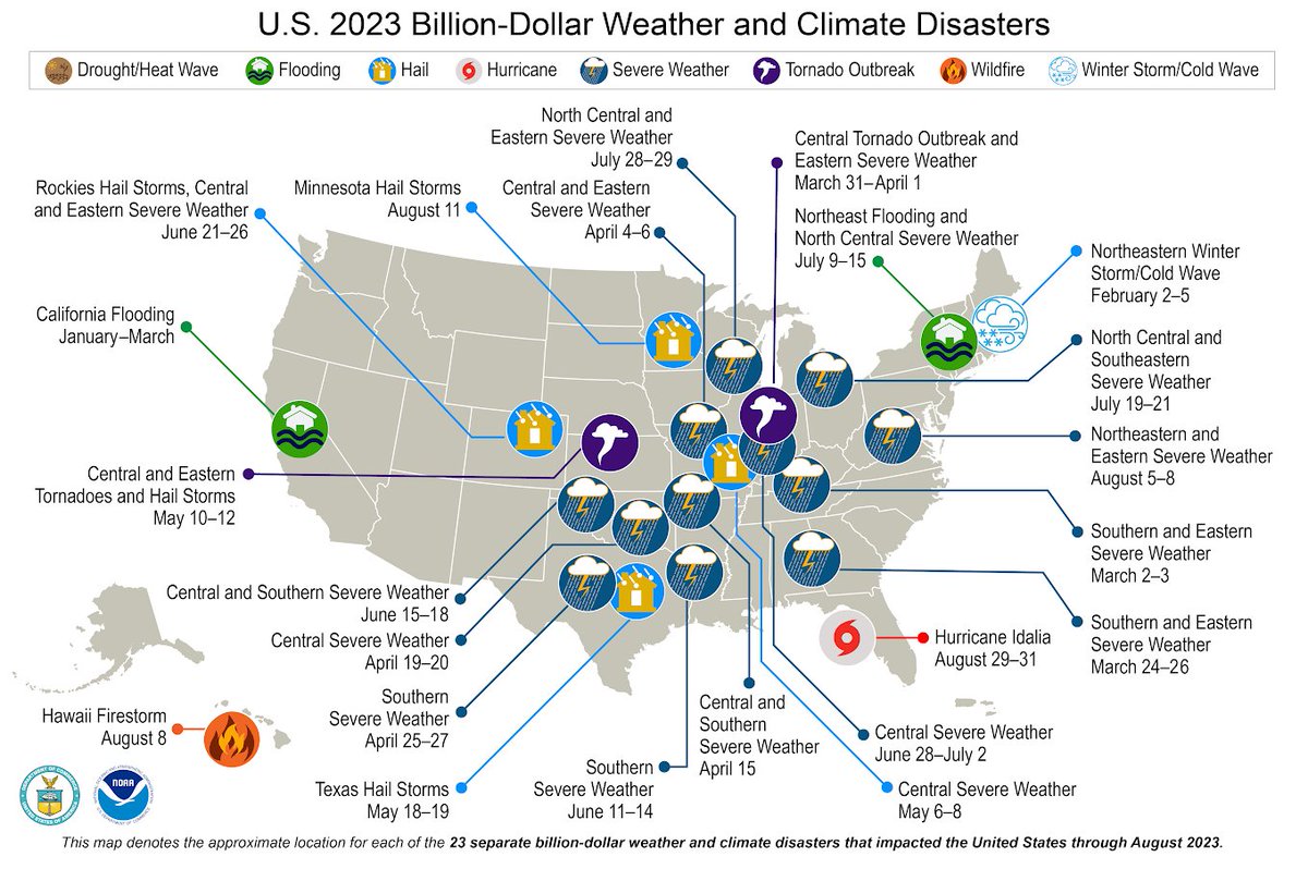
(1 of 5) JUST IN: The all-time highest number of billion dollar disasters on record occurred.

23 confirmed year-to-date B$D events.

More from our 2023 .

Report: bit.ly/484dO3M

NOAA NCEI

(1 of 5) JUST IN: The all-time highest number of billion dollar disasters on record occurred. 23 confirmed year-to-date B$D events. More from our #August 2023 #StateofClimate. Report: bit.ly/484dO3M @NOAANCEI #Climate
account_circle
NWS Columbia(@NWSColumbia) 's Twitter Profile Photo

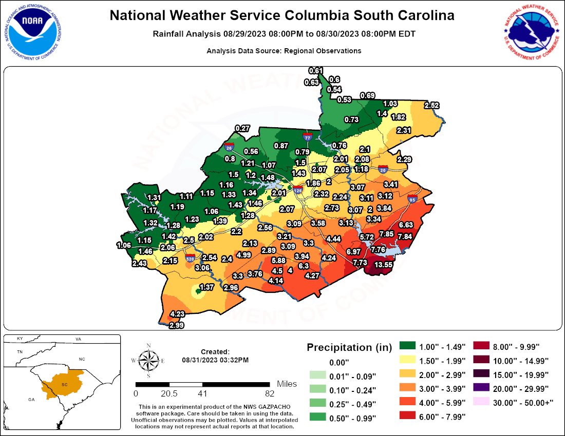
Here is a final map of the rainfall totals from yesterday, with several areas in the eastern Midlands seeing more rain in one day than is normal for the entire month of August!

Here is a final map of the rainfall totals from yesterday, with several areas in the eastern Midlands seeing more rain in one day than is normal for the entire month of August! #scwx #gawx
account_circle
Steve Bowen(@SteveBowenWx) 's Twitter Profile Photo

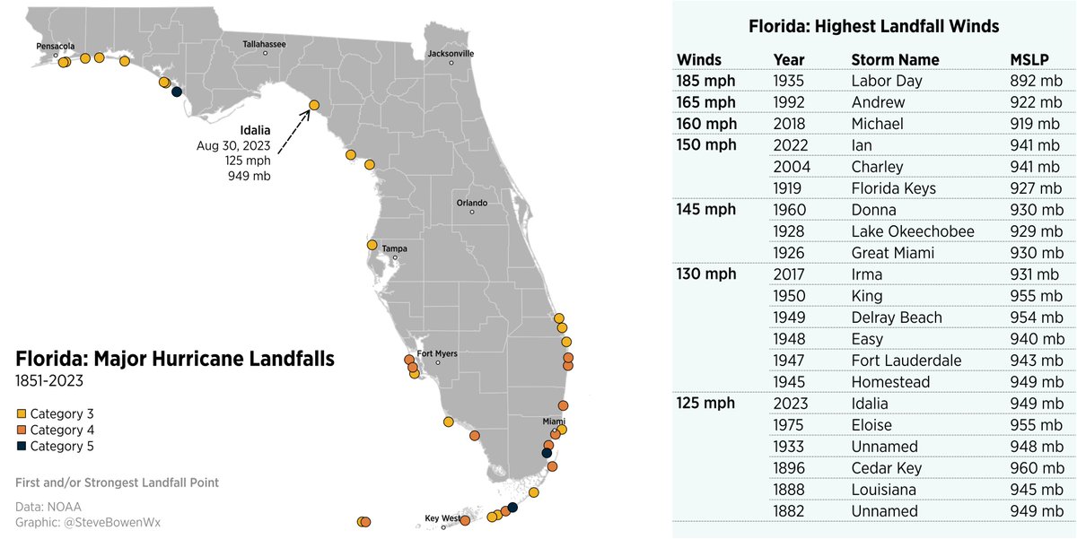
becomes the first Category 3+ storm to strike Taylor County, on record dating to 1851.

It is one of 21 hurricanes known to strike Florida with at least 125 mph winds.

Florida has recorded four ≥125 mph landfall events since 2017 (Irma, Michael, Ian, Idalia).

#Idalia becomes the first Category 3+ storm to strike Taylor County, #Florida on record dating to 1851. It is one of 21 hurricanes known to strike Florida with at least 125 mph winds. Florida has recorded four ≥125 mph landfall events since 2017 (Irma, Michael, Ian, Idalia).
account_circle
NWS Columbia(@NWSColumbia) 's Twitter Profile Photo

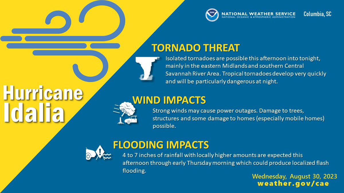
will move through the area this afternoon through early Thursday morning bringing heavy rainfall, strong and gusty winds and the potential for isolated tornadoes. Stay weather aware and make sure you have at least two ways to receive NWS warnings.

#Idalia will move through the area this afternoon through early Thursday morning bringing heavy rainfall, strong and gusty winds and the potential for isolated tornadoes. Stay weather aware and make sure you have at least two ways to receive NWS warnings. #CAWx #SCWx #GAWx
account_circle
National Hurricane Center(@NHC_Atlantic) 's Twitter Profile Photo

7:45 AM EDT update: Extremely dangerous Category 3 Hurricane makes landfall in the Florida Big Bend. Maximum sustained winds were estimated to be 125 mph. Catastrophic storm surge and damaging winds ongoing.

7:45 AM EDT update: Extremely dangerous Category 3 Hurricane #Idalia makes landfall in the Florida Big Bend. Maximum sustained winds were estimated to be 125 mph. Catastrophic storm surge and damaging winds ongoing.
account_circle
NWS Columbia(@NWSColumbia) 's Twitter Profile Photo

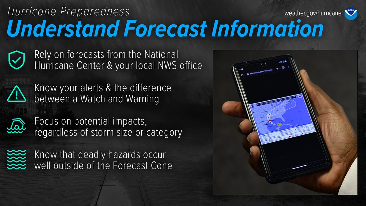
Be prepared for hurricanes by knowing how to understand forecasts. They can tell you a lot about what is expected, including the storm’s path, rainfall amounts, wind speeds, and more. noaa.gov/understand-for…

Be prepared for hurricanes by knowing how to understand forecasts. They can tell you a lot about what is expected, including the storm’s path, rainfall amounts, wind speeds, and more. #HurricanePrep #HurricaneStrong noaa.gov/understand-for…
account_circle
NWS Columbia(@NWSColumbia) 's Twitter Profile Photo

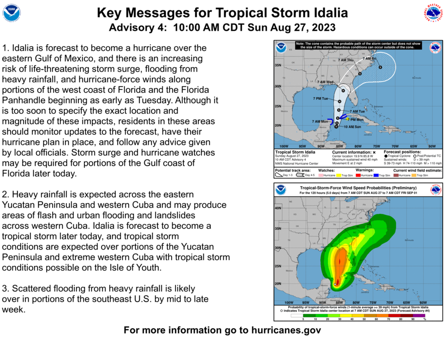
Tropical Storm (ee-DAL-ya) has formed based on aircraft reconnaissance. Here are the latest forecast track and key messages from the National Hurricane Center.

Tropical Storm #Idalia (ee-DAL-ya) has formed based on aircraft reconnaissance. Here are the latest forecast track and key messages from the National Hurricane Center. #CAEWx #SCWx #GAWx
account_circle
NWS Columbia(@NWSColumbia) 's Twitter Profile Photo

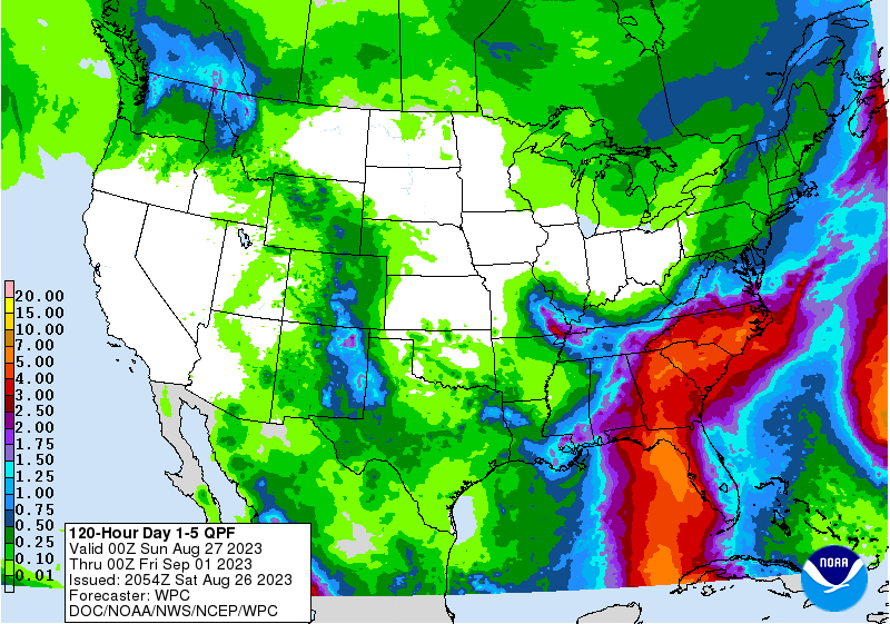
Tropical Depression 10 has formed off the Yucatan. The system is expected to move north early next week, possibly into the Southeast US. A stalled front + tropical moisture are expected to produce widespread heavy rain for us, regardless of the exact track or strength.

Tropical Depression 10 has formed off the Yucatan. The system is expected to move north early next week, possibly into the Southeast US. A stalled front + tropical moisture are expected to produce widespread heavy rain for us, regardless of the exact track or strength.
account_circle