NWS Houston(@NWSHouston) 's Twitter Profile Photo

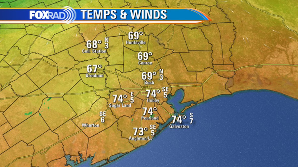
Warm and humid conditions, along with some isolated showers and storms, are expected today. Most of the area will see highs in the upper 70s to lower 80s and lows in the 60s to near 70.

Warm and humid conditions, along with some isolated showers and storms, are expected today. Most of the area will see highs in the upper 70s to lower 80s and lows in the 60s to near 70. #houwx #txwx
account_circle
NWS Houston(@NWSHouston) 's Twitter Profile Photo

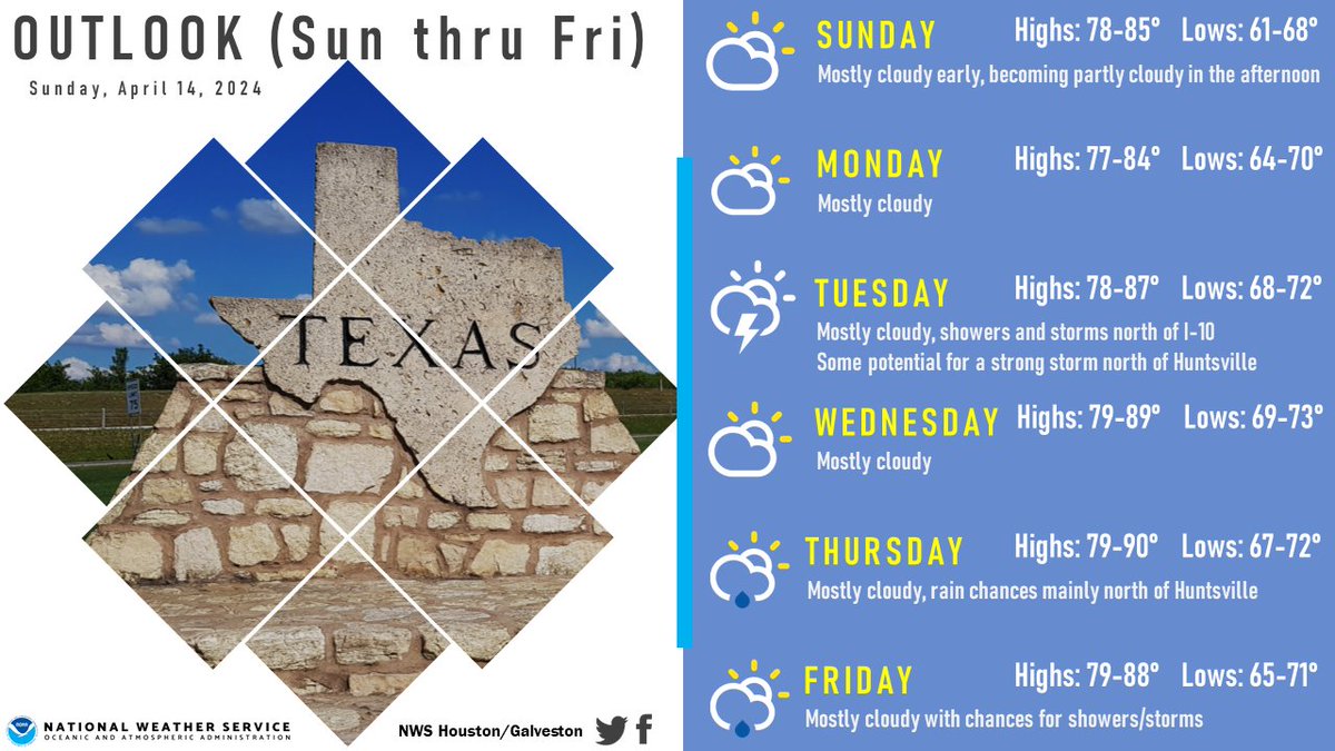
A gradual warming trend can be expected across much of SE TX over the next several days. Some spots could approach 90 degrees for highs on Wednesday and/or Thursday. Want it to get cooler again? Maybe next weekend.

A gradual warming trend can be expected across much of SE TX over the next several days. Some spots could approach 90 degrees for highs on Wednesday and/or Thursday. Want it to get cooler again?  Maybe next weekend. #txwx #houwx #glswx #bcswx
account_circle
NWS Houston(@NWSHouston) 's Twitter Profile Photo

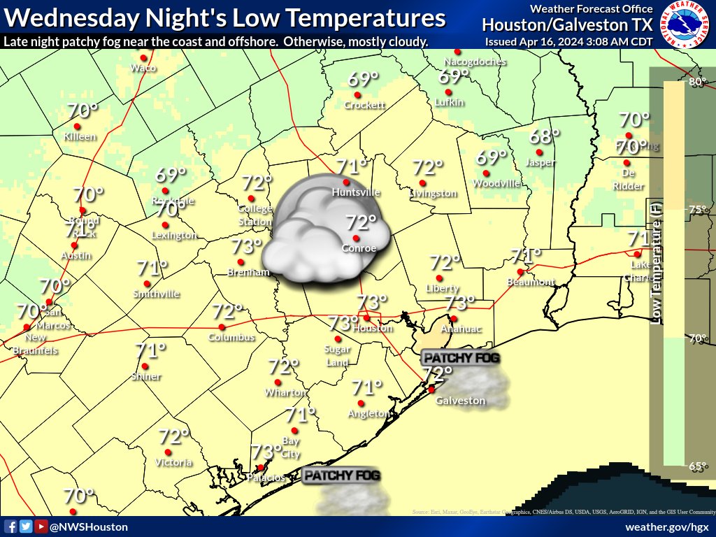
Here are the latest SE TX temp outlooks for today/ tonight/Wednesday/Wednesday night. Today: warm/breezy. Tonight: patchy fog possible late. Wednesday: patchy fog possible early. Wednesday night: late night patchy fog possible near the coast & offshore.

Here are the latest SE TX temp outlooks for today/ tonight/Wednesday/Wednesday night. Today: warm/breezy. Tonight: patchy fog possible late. Wednesday: patchy fog possible early. Wednesday night: late night patchy fog possible near the coast & offshore. #txwx #houwx #glswx #bcswx
account_circle
NWS Houston(@NWSHouston) 's Twitter Profile Photo

Here are the expected weekend temeperatures (today's highs, tonight's low, Sunday's highs and Sunday night's lows) across SE TX. Look for gradually rising humidities due to increasing/strengthening south to southeast winds.

Here are the expected weekend temeperatures (today's highs, tonight's low, Sunday's highs and Sunday night's lows) across SE TX. Look for gradually rising humidities due to increasing/strengthening south to southeast winds. #txwx #houwx #glswx #bcswx
account_circle
NWS Houston(@NWSHouston) 's Twitter Profile Photo

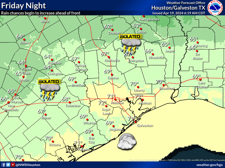
Temperatures today will reach near 90°F in some spots as the warming trend continues. 🌡️ A cold front approaches SE TX tonight, but stalls out just north of the area. Some scattered storms are possible around the Brazos Valley/Piney Woods overnight.

Temperatures today will reach near 90°F in some spots as the warming trend continues. 🌡️ A cold front approaches SE TX tonight, but stalls out just north of the area. Some scattered storms are possible around the Brazos Valley/Piney Woods overnight. #TXwx #HOUwx #BCSwx #GLSwx
account_circle
NWS Houston(@NWSHouston) 's Twitter Profile Photo

Quiet, pleasant weather should continue across SE Texas into the beginning of next week. Lows tonight will be in the 60s to lower 70s. Highs on Monday will be in the mid/lower 80s inland and 70s near the coast.

Quiet, pleasant weather should continue across SE Texas into the beginning of next week. Lows tonight will be in the 60s to lower 70s. Highs on Monday will be in the mid/lower 80s inland and 70s near the coast. #TXwx #HOUwx
account_circle
NWS Houston(@NWSHouston) 's Twitter Profile Photo

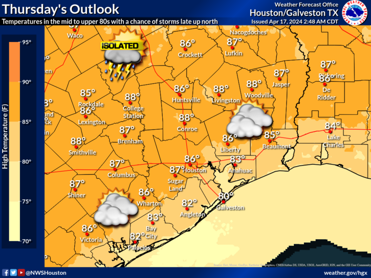
The warming trend continues as we'll see temperatures in the low to mid 80s today and then in the mid to upper 80s on Thursday. Patchy fog is ongoing in some spots this morning and we're expecting another round on Thursday morning.

The warming trend continues as we'll see temperatures in the low to mid 80s today and then in the mid to upper 80s on Thursday. Patchy fog is ongoing in some spots this morning and we're expecting another round on Thursday morning. #TXwx #HOUwx #BCSwx #GLSwx
account_circle
NWS Houston(@NWSHouston) 's Twitter Profile Photo

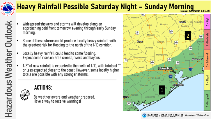
We are keeping an eye on the heavy rainfall potential Saturday night - Sunday morning. Though widespread rainfall amounts appear manageable, locally heavier totals could result in localized flooding.

Stay weather aware y'all!

We are keeping an eye on the heavy rainfall potential Saturday night - Sunday morning. Though widespread rainfall amounts appear manageable, locally heavier totals could result in localized flooding. 

Stay weather aware y'all! 

#HOUwx #BCSwx #TXwx
account_circle
Karen Yip(@KBYip) 's Twitter Profile Photo

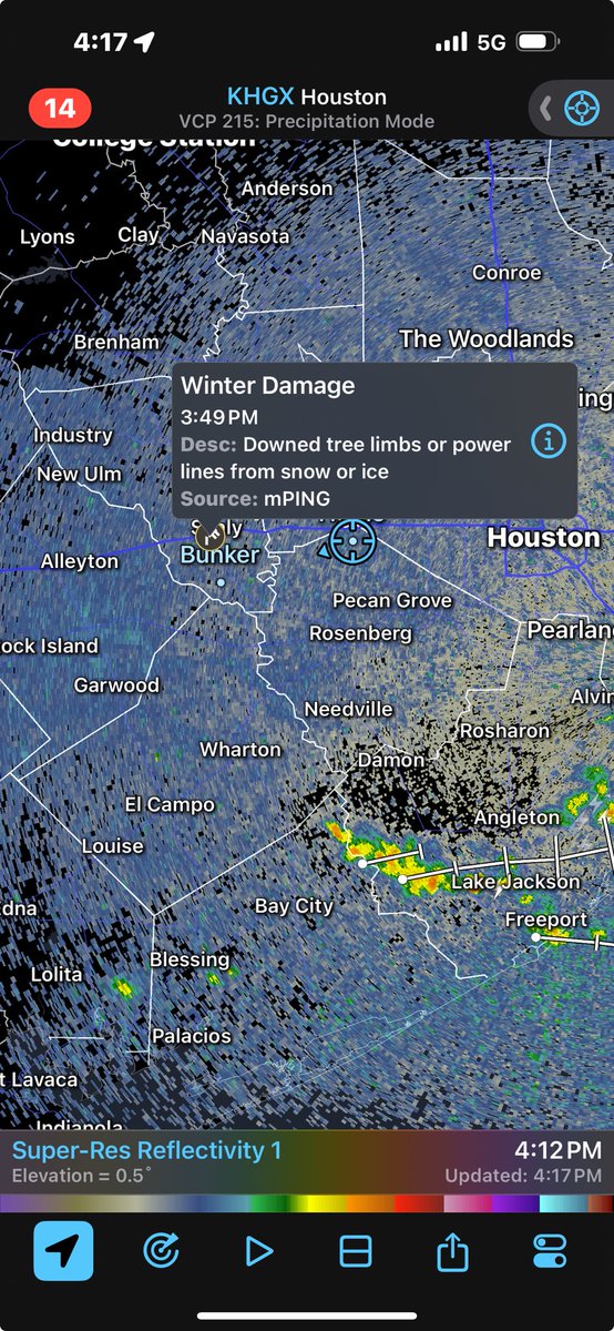
Well our zero % probability of rain is now damp with thunderstorms ⚡️🌩️⛈️
My garden is thrilled for the drink but wow what a surprise. Eric Berger

Well our zero % probability of rain is now damp with thunderstorms ⚡️🌩️⛈️
My garden is thrilled for the drink but wow what a surprise. #HouWx @SpaceCityWX
account_circle
NWS Houston(@NWSHouston) 's Twitter Profile Photo

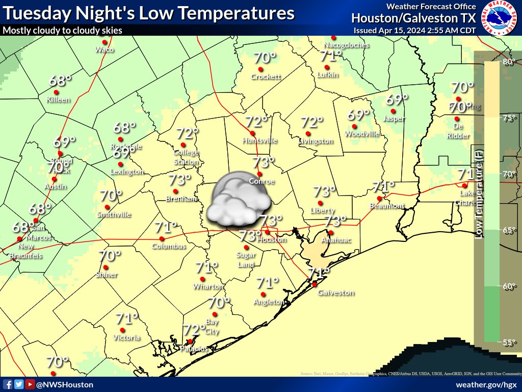
Here are the SE TX temperature outlooks for today, tonight, Tuesday and Tuesday night. Mostly cloudy to cloudy skies can be expected, and it will occasionally be breezy. Isolated showers/storms possible Tuesday portions of Brazos Valley/Piney Woods.

Here are the SE TX temperature outlooks for today, tonight, Tuesday and Tuesday night. Mostly cloudy to cloudy skies can be expected, and it will occasionally be breezy. Isolated showers/storms possible Tuesday portions of Brazos Valley/Piney Woods. #txwx #houwx #glswx #bcswx
account_circle